Online Resource List
Get a list of Instrument objects. Instruments have a 1:1 mapping with Observations.
GET /api/v3/onlineresources/?format=api&offset=13600
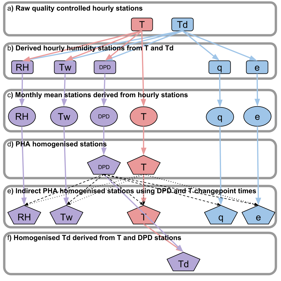
{ "count": 87423, "next": "https://api.catalogue.ceda.ac.uk/api/v3/onlineresources/?format=api&limit=100&offset=13700", "previous": "https://api.catalogue.ceda.ac.uk/api/v3/onlineresources/?format=api&limit=100&offset=13500", "results": [ { "ob_id": 15701, "function": "documentation", "linkage": "https://earth.esa.int/web/guest/data-access/browse-data-products/-/asset_publisher/y8Qb/content/atsr-averaged-surface-temperature-5022?redirect=https%3A%2F%2Fearth.esa.int%2Fweb%2Fguest%2Fdata-access%2Fbrowse-data-products%3Fp_p_id%3D101_INSTANCE_y8Qb%26p_p_lifecycle%3D0%26p_p_state%3Dnormal%26p_p_mode%3Dview%26p_p_col_id%3Dcolumn-1%26p_p_col_pos%3D1%26p_p_col_count%3D2", "name": "ESA Data Catalogue", "relatedTo": { "ob_id": 19744, "uuid": "289126a92b7a4b8a9ac69714263c1c1d", "short_code": "ob" } }, { "ob_id": 15702, "function": "documentation", "linkage": "https://earth.esa.int/web/guest/data-access/browse-data-products/-/asset_publisher/y8Qb/content/atsr-averaged-surface-temperature-5022?redirect=https%3A%2F%2Fearth.esa.int%2Fweb%2Fguest%2Fdata-access%2Fbrowse-data-products%3Fp_p_id%3D101_INSTANCE_y8Qb%26p_p_lifecycle%3D0%26p_p_state%3Dnormal%26p_p_mode%3Dview%26p_p_col_id%3Dcolumn-1%26p_p_col_pos%3D1%26p_p_col_count%3D2", "name": "ESA Data Catalogue", "relatedTo": { "ob_id": 19746, "uuid": "320fec47a9184273a08d268137036e8d", "short_code": "ob" } }, { "ob_id": 15703, "function": "documentation", "linkage": "https://earth.esa.int/documents/10174/481651/ATSR_3rd_Reprocessing_User_Note_1-0.pdf", "name": "Information on the third reprocessing", "relatedTo": { "ob_id": 19746, "uuid": "320fec47a9184273a08d268137036e8d", "short_code": "ob" } }, { "ob_id": 15704, "function": "documentation", "linkage": "http://www.resc.rdg.ac.uk/myocean/MYO-WP04-ScVR-rea-UReading_v2.1.pdf", "name": "M. Valdivieso, K. Haines and H. Zuo, 2012: MyOcean Scientific Validation Report (ScVR) for v2.1 Reprocessed Analysis and Reanalysis. GMES Marine Core Services Technical Report WP04-GLO-U-Reading_v2.1, 61 pp, February 2012.", "relatedTo": { "ob_id": 19748, "uuid": "1d95d0bc906c47f5932929c28e927f06", "short_code": "ob" } }, { "ob_id": 15705, "function": "documentation", "linkage": "http://onlinelibrary.wiley.com/doi/10.1029/2012GL054581/abstract", "name": "Haines K., Stepanov V. N., Valdivieso M. and Zuo H. (2013) Atlantic meridional heat transports in two ocean reanalyses evaluated against the RAPID array, Geophys. Res. Lett., 40, 343–348, doi:10.1029/2012GL054581 ", "relatedTo": { "ob_id": 19748, "uuid": "1d95d0bc906c47f5932929c28e927f06", "short_code": "ob" } }, { "ob_id": 15706, "function": "documentation", "linkage": "http://data.ceda.ac.uk/badc/rapid-watch/metadata/Sutton/VALOR/MYO-WP04-ScVR-rea-UReading_v2.1.pdf", "name": "MyOcean Validation Report", "relatedTo": { "ob_id": 19748, "uuid": "1d95d0bc906c47f5932929c28e927f06", "short_code": "ob" } }, { "ob_id": 15707, "function": "documentation", "linkage": "http://sohowww.nascom.nasa.gov/about/instruments.html", "name": "SOHO Instruments", "relatedTo": { "ob_id": 10935, "uuid": "2c0bb6679e4f4a0ba1bc254167b171d8", "short_code": "ob" } }, { "ob_id": 15708, "function": "documentation", "linkage": "http://sohowww.nascom.nasa.gov/", "name": "NASA SOHO Home Page", "relatedTo": { "ob_id": 10935, "uuid": "2c0bb6679e4f4a0ba1bc254167b171d8", "short_code": "ob" } }, { "ob_id": 15709, "function": "documentation", "linkage": "http://data.ceda.ac.uk/badc/ukmo-hadobs/metadata/HadISD/HadISD_v103_stations.csv", "name": "HadISD station ID codes", "relatedTo": { "ob_id": 13557, "uuid": "229b53d2e44741ecbe70ba6299875a30", "short_code": "ob" } }, { "ob_id": 15710, "function": "documentation", "linkage": "https://zenodo.org/record/7356963/files/HadISD_file_format_guide.pdf", "name": "HadISD data format", "relatedTo": { "ob_id": 13557, "uuid": "229b53d2e44741ecbe70ba6299875a30", "short_code": "ob" } }, { "ob_id": 15711, "function": "documentation", "linkage": "http://www.ukssdc.ac.uk/cgi-bin/wdcc1/secure/iono_availability.pl", "name": "Data Availability Search", "relatedTo": { "ob_id": 10955, "uuid": "f2bd3cf541b24177bfc33dc0dc48695d", "short_code": "ob" } }, { "ob_id": 15712, "function": "documentation", "linkage": "http://www.ukssdc.ac.uk/wdcc1/ionosondes/ursi_codes.html", "name": "Ionospheric Parameter Codes", "relatedTo": { "ob_id": 10955, "uuid": "f2bd3cf541b24177bfc33dc0dc48695d", "short_code": "ob" } }, { "ob_id": 15713, "function": "documentation", "linkage": "http://www.ukssdc.ac.uk/wdcc1/ionosondes/letters.html", "name": "UK Panel of the International Union for Radio Science (URSI) Qualifying and Descriptive Letters", "relatedTo": { "ob_id": 10955, "uuid": "f2bd3cf541b24177bfc33dc0dc48695d", "short_code": "ob" } }, { "ob_id": 15714, "function": "documentation", "linkage": "http://spears.lancs.ac.uk/cgi-bin/riometers", "name": "Lancaster University Riometer and Imaging Riometer Database", "relatedTo": { "ob_id": 10957, "uuid": "ab9bf1524e134398b693f09b5199412b", "short_code": "ob" } }, { "ob_id": 15715, "function": "documentation", "linkage": "http://www.ukssdc.ac.uk/wdcc1/data-offline.html", "name": "UKSSDC Offline Data Holdings", "relatedTo": { "ob_id": 10957, "uuid": "ab9bf1524e134398b693f09b5199412b", "short_code": "ob" } }, { "ob_id": 15716, "function": "documentation", "linkage": "http://www.ukssdc.ac.uk/ionosondes/ionosondes.html", "name": "Rutherford Appleton Laboratory (RAL) Ionospheric Monitoring Group ", "relatedTo": { "ob_id": 10953, "uuid": "66486d43646c4f9db8bbde0efe1694ab", "short_code": "ob" } }, { "ob_id": 15717, "function": "documentation", "linkage": "http://www.ukssdc.ac.uk/prompt_database.html", "name": "UKSSDC Prompt Ionospheric Database", "relatedTo": { "ob_id": 10967, "uuid": "6a7935465d374c7a9eac70c046f4cfcb", "short_code": "ob" } }, { "ob_id": 15718, "function": "documentation", "linkage": "http://vestige.lmsal.com/TRACE/Project/Instrument/insrument.htm", "name": "TRACE Instrumentation", "relatedTo": { "ob_id": 10947, "uuid": "5116f09e13c84454888fd0e2466352ec", "short_code": "ob" } }, { "ob_id": 15719, "function": "documentation", "linkage": "http://www.ukssdc.ac.uk/solar/trace/", "name": "UKSSDC: TRACE archive home page", "relatedTo": { "ob_id": 10947, "uuid": "5116f09e13c84454888fd0e2466352ec", "short_code": "ob" } }, { "ob_id": 15720, "function": "documentation", "linkage": "http://trace.lmsal.com/", "name": "TRACE home page", "relatedTo": { "ob_id": 10947, "uuid": "5116f09e13c84454888fd0e2466352ec", "short_code": "ob" } }, { "ob_id": 15721, "function": "documentation", "linkage": "http://www.stereo.rl.ac.uk/", "name": "STEREO Homepage at SFTC Rutherford Appleton Laboratory", "relatedTo": { "ob_id": 10937, "uuid": "dc8c9a1dfba24a0187e22740404385fd", "short_code": "ob" } }, { "ob_id": 15722, "function": "documentation", "linkage": "http://stereo.gsfc.nasa.gov/", "name": "STEREO Homepage at NASA", "relatedTo": { "ob_id": 10937, "uuid": "dc8c9a1dfba24a0187e22740404385fd", "short_code": "ob" } }, { "ob_id": 15723, "function": "documentation", "linkage": "http://www.ukssdc.ac.uk/contact.html", "name": "UK Solar System Data Centre (UKSSDC) Support", "relatedTo": { "ob_id": 10945, "uuid": "3922e45b2d764ae196cb06a941e1beb7", "short_code": "ob" } }, { "ob_id": 15724, "function": "documentation", "linkage": "http://www.ukssdc.ac.uk/wdcc1/ionosondes/letters.html", "name": "UK Panel of the International Union for Radio Science (URSI) Qualifying and Descriptive Letters for Ionospheric Parameters", "relatedTo": { "ob_id": 10945, "uuid": "3922e45b2d764ae196cb06a941e1beb7", "short_code": "ob" } }, { "ob_id": 15725, "function": "documentation", "linkage": "http://www.ukssdc.ac.uk/wdcc1/iiwg_menu.html", "name": "Ionospheric Informatics Working Group (IIWG) Data Retrieval", "relatedTo": { "ob_id": 10945, "uuid": "3922e45b2d764ae196cb06a941e1beb7", "short_code": "ob" } }, { "ob_id": 15726, "function": "documentation", "linkage": "http://www.ukssdc.ac.uk/wdcc1/ionosondes/ursi_codes.html", "name": "UK Panel of the International Union for Radio Science (URSI) Ionospheric Parameter Codes", "relatedTo": { "ob_id": 10945, "uuid": "3922e45b2d764ae196cb06a941e1beb7", "short_code": "ob" } }, { "ob_id": 15727, "function": "documentation", "linkage": "http://www.ukssdc.ac.uk/wdcc1/ionosondes/iiwg_format.html", "name": "Ionospheric Informatics Working Group (IIWG) Format Description", "relatedTo": { "ob_id": 10945, "uuid": "3922e45b2d764ae196cb06a941e1beb7", "short_code": "ob" } }, { "ob_id": 15728, "function": "documentation", "linkage": "http://www.ukssdc.ac.uk/wdcc1/reports_menu.html", "name": "World Data Centre (WDC) for Solar-Terrestrial Physics, Chilton, Reports", "relatedTo": { "ob_id": 10941, "uuid": "54988e5b7aff4e929ac02e73f3c777ca", "short_code": "ob" } }, { "ob_id": 15729, "function": "documentation", "linkage": "http://www.ukssdc.ac.uk/wdcc1/reports_menu.html", "name": "World Data Centre (WDC) for Solar-Terrestrial Physics, Chilton, Reports", "relatedTo": { "ob_id": 19756, "uuid": "c79b18c2fcdf41ada4b8e1562bea7411", "short_code": "ob" } }, { "ob_id": 15730, "function": "documentation", "linkage": "http://www.ukssdc.ac.uk/wdcc1/reports_menu.html", "name": "World Data Centre (WDC) for Solar-Terrestrial Physics, Chilton, Reports", "relatedTo": { "ob_id": 19758, "uuid": "afed8436512e4bc1b02320e18132815f", "short_code": "ob" } }, { "ob_id": 15731, "function": "documentation", "linkage": "http://www.ukssdc.ac.uk/wdcc1/reports_menu.html", "name": "World Data Centre (WDC) for Solar-Terrestrial Physics, Chilton, Reports", "relatedTo": { "ob_id": 19759, "uuid": "b9bae3ebc72643b0a91396064097bf74", "short_code": "ob" } }, { "ob_id": 15732, "function": "documentation", "linkage": "http://www.ukssdc.ac.uk/wdcc1/reports_menu.html", "name": "World Data Centre (WDC) for Solar-Terrestrial Physics, Chilton, Reports", "relatedTo": { "ob_id": 19760, "uuid": "db756b9651da4e11b9ca2a0c3cce64b1", "short_code": "ob" } }, { "ob_id": 15733, "function": "documentation", "linkage": "http://www.ukssdc.ac.uk/wdcc1/reports_menu.html", "name": "World Data Centre (WDC) for Solar-Terrestrial Physics, Chilton, Reports", "relatedTo": { "ob_id": 19761, "uuid": "2413d567033a4915bf1457c7b362c79b", "short_code": "ob" } }, { "ob_id": 15734, "function": "documentation", "linkage": "http://www.ukssdc.ac.uk/wdcc1/reports_menu.html", "name": "World Data Centre (WDC) for Solar-Terrestrial Physics, Chilton, Reports", "relatedTo": { "ob_id": 19762, "uuid": "980a7c11d834455eb75752fdf7830719", "short_code": "ob" } }, { "ob_id": 15735, "function": "documentation", "linkage": "http://mst.nerc.ac.uk/", "name": "MST Radar Facility website", "relatedTo": { "ob_id": 12444, "uuid": "92d6475925224211b255fabe55161ea1", "short_code": "ob" } }, { "ob_id": 15744, "function": "documentation", "linkage": "http://journals.ametsoc.org/doi/abs/10.1175/2011BAMS3015.1", "name": "Integrated surface database reference paper", "relatedTo": { "ob_id": 13528, "uuid": "fd038d5dcba14f58ac2770ad47acf39c", "short_code": "ob" } }, { "ob_id": 15746, "function": "documentation", "linkage": "http://journals.ametsoc.org/doi/abs/10.1175/2011BAMS3015.1", "name": "Integrated surface database reference paper", "relatedTo": { "ob_id": 13522, "uuid": "251474c7b09449d8b9e7aeaf1461858f", "short_code": "coll" } }, { "ob_id": 15747, "function": "documentation", "linkage": "http://journals.ametsoc.org/doi/abs/10.1175/2011BAMS3015.1", "name": "Integrated surface database reference paper", "relatedTo": { "ob_id": 19171, "uuid": "f34f97696cd94946b6ace2e8738df805", "short_code": "ob" } }, { "ob_id": 15748, "function": "documentation", "linkage": "http://data.ceda.ac.uk/badc/ukmo-hadobs/metadata/HadISD/HadISD_v103_stations.csv", "name": "HadISD station ID codes", "relatedTo": { "ob_id": 19173, "uuid": "7b6993cbf7ec45f9ad01b86bed537e4c", "short_code": "ob" } }, { "ob_id": 15749, "function": "documentation", "linkage": "https://zenodo.org/record/7356963/files/HadISD_file_format_guide.pdf", "name": "HadISD data format", "relatedTo": { "ob_id": 19173, "uuid": "7b6993cbf7ec45f9ad01b86bed537e4c", "short_code": "ob" } }, { "ob_id": 15750, "function": "documentation", "linkage": "http://journals.ametsoc.org/doi/abs/10.1175/2011BAMS3015.1", "name": "Integrated surface database reference paper", "relatedTo": { "ob_id": 19173, "uuid": "7b6993cbf7ec45f9ad01b86bed537e4c", "short_code": "ob" } }, { "ob_id": 15751, "function": "documentation", "linkage": "http://journals.ametsoc.org/doi/abs/10.1175/2011BAMS3015.1", "name": "Integrated surface database reference paper", "relatedTo": { "ob_id": 13557, "uuid": "229b53d2e44741ecbe70ba6299875a30", "short_code": "ob" } }, { "ob_id": 15752, "function": "documentation", "linkage": "http://www.rapid.ac.uk/", "name": "RAPID website", "relatedTo": { "ob_id": 19812, "uuid": "34f3219ef1fb4116a977c4d8fea4212f", "short_code": "proj" } }, { "ob_id": 15753, "function": "documentation", "linkage": "http://data.ceda.ac.uk/badc/ukmo-lidarnet/plots/camborne/vaisala-cl31", "name": "Daily plots of Met Office LIDARNET Camborne Vaisala CL31 ceilometer cloud base and backscatter data", "relatedTo": { "ob_id": 12556, "uuid": "113b3bd55eb54aff9d515bf5403a71db", "short_code": "ob" } }, { "ob_id": 15754, "function": "documentation", "linkage": "http://data.ceda.ac.uk/badc/ukmo-lidarnet/plots/coningsby/vaisala-cl31", "name": "Daily plots of Met Office LIDARNET Coningsby Vaisala CL31 ceilometer cloud base and backscatter data", "relatedTo": { "ob_id": 12559, "uuid": "f0145253352846b4b6d2ad96f0c346f4", "short_code": "ob" } }, { "ob_id": 15755, "function": "documentation", "linkage": "http://data.ceda.ac.uk/badc/ukmo-lidarnet/plots/st-helena/vaisala-ct25k", "name": "Daily plots of Met Office LIDARNET St Helena Vaisala CT25k ceilometer cloud base and backscatter data", "relatedTo": { "ob_id": 12632, "uuid": "989f968fada24d5db6720daba5238a48", "short_code": "ob" } }, { "ob_id": 15756, "function": "documentation", "linkage": "http://data.ceda.ac.uk/badc/ukmo-lidarnet/plots/cranwell/vaisala-cl31", "name": "Daily plots of Met Office LIDARNET Cranwell Vaisala CL31 ceilometer cloud base and backscatter data", "relatedTo": { "ob_id": 12562, "uuid": "325bb08ec6784b76b3daa37ce7147312", "short_code": "ob" } }, { "ob_id": 15757, "function": "documentation", "linkage": "http://data.ceda.ac.uk/badc/ukmo-lidarnet/plots/culdrose/vaisala-cl31", "name": "Daily plots of Met Office LIDARNET Culdrose Vaisala CL31 ceilometer cloud base and backscatter data", "relatedTo": { "ob_id": 12565, "uuid": "ff07293207a44ce8b88ea099b20bc9d5", "short_code": "ob" } }, { "ob_id": 15758, "function": "documentation", "linkage": "http://data.ceda.ac.uk/badc/ukmo-lidarnet/plots/aberporth/vaisala-cl31", "name": "Daily plots of Met Office LIDARNET Aberporth Vaisala CL31 ceilometer cloud base and backscatter data", "relatedTo": { "ob_id": 12439, "uuid": "781bb3981efa48dcae5e14546b312e4b", "short_code": "ob" } }, { "ob_id": 15759, "function": "documentation", "linkage": "http://data.ceda.ac.uk/badc/ukmo-lidarnet/plots/dishforth/vaisala-cl31", "name": "Daily plots of Met Office LIDARNET Dishforth Vaisala CL31 ceilometer cloud base and backscatter data", "relatedTo": { "ob_id": 12568, "uuid": "141e5b3047bf4f6dac11bcdc4372c1ea", "short_code": "ob" } }, { "ob_id": 15760, "function": "documentation", "linkage": "http://data.ceda.ac.uk/badc/ukmo-lidarnet/plots/eskdalemuir/vaisala-cl31", "name": "Daily plots of Met Office LIDARNET Eskdalemuir Vaisala CL31 ceilometer cloud base and backscatter data", "relatedTo": { "ob_id": 12571, "uuid": "b863eac203c44ae58e1f5384fd09c4aa", "short_code": "ob" } }, { "ob_id": 15761, "function": "documentation", "linkage": "http://data.ceda.ac.uk/badc/ukmo-lidarnet/plots/exeter/vaisala-cl31", "name": "Daily plots of Met Office LIDARNET Exeter Vaisala CL31 ceilometer cloud base and backscatter data", "relatedTo": { "ob_id": 12574, "uuid": "2bd9bd4d03e64545b744c062f6e86a33", "short_code": "ob" } }, { "ob_id": 15762, "function": "documentation", "linkage": "http://data.ceda.ac.uk/badc/ukmo-lidarnet/plots/northolt/vaisala-ct25k/", "name": "Daily plots of Met Office LIDARNET Northolt Vaisala CT25k ceilometer cloud base and backscatter data", "relatedTo": { "ob_id": 12448, "uuid": "b1e2f90ef234469fa313b4fc3630581e", "short_code": "ob" } }, { "ob_id": 15763, "function": "documentation", "linkage": "http://data.ceda.ac.uk/badc/ukmo-lidarnet/plots/gibraltar/vaisala-cl31", "name": "Daily plots of Met Office LIDARNET Gibraltar Vaisala CL31 ceilometer cloud base and backscatter data", "relatedTo": { "ob_id": 12577, "uuid": "05e34382adfa46f6987aa1315f2ca7e4", "short_code": "ob" } }, { "ob_id": 15764, "function": "documentation", "linkage": "http://data.ceda.ac.uk/badc/ukmo-lidarnet/plots/wittering/vaisala-ct25k", "name": "Daily plots of Met Office LIDARNET Wittering Vaisala CT25k ceilometer cloud base and backscatter data", "relatedTo": { "ob_id": 12635, "uuid": "bf805d665f3b49c292dd3abb41479baa", "short_code": "ob" } }, { "ob_id": 15765, "function": "documentation", "linkage": "http://data.ceda.ac.uk/badc/ukmo-lidarnet/plots/kinloss/vaisala-cl31", "name": "Daily plots of Met Office LIDARNET Kinloss Vaisala CL31 ceilometer cloud base and backscatter data", "relatedTo": { "ob_id": 12580, "uuid": "f1037cddae24488b9c9129542493a593", "short_code": "ob" } }, { "ob_id": 15766, "function": "documentation", "linkage": "http://data.ceda.ac.uk/badc/ukmo-lidarnet/plots/larkhill/vaisala-cl31", "name": "Daily plots of Met Office LIDARNET Larkhill Vaisala CL31 ceilometer cloud base and backscatter data", "relatedTo": { "ob_id": 12583, "uuid": "48a2f2b7098f457c8b88e1e3b8e38b35", "short_code": "ob" } }, { "ob_id": 15767, "function": "documentation", "linkage": "http://data.ceda.ac.uk/badc/ukmo-lidarnet/plots/leeming/vaisala-cl31", "name": "Daily plots of Met Office LIDARNET Leeming Vaisala CL31 ceilometer cloud base and backscatter data", "relatedTo": { "ob_id": 12586, "uuid": "7517c43d390e483980a4ba7fb3890aaa", "short_code": "ob" } }, { "ob_id": 15768, "function": "documentation", "linkage": "http://data.ceda.ac.uk/badc/ukmo-lidarnet/plots/lerwick/vaisala-cl31", "name": "Daily plots of Met Office LIDARNET Lerwick Vaisala CL31 ceilometer cloud base and backscatter data", "relatedTo": { "ob_id": 12589, "uuid": "50a8d8a2be494a1ab69c5ac774ed863e", "short_code": "ob" } }, { "ob_id": 15769, "function": "documentation", "linkage": "http://data.ceda.ac.uk/badc/ukmo-lidarnet/plots/leuchars/vaisala-cl31", "name": "Daily plots of Met Office LIDARNET Leuchars Vaisala CL31 ceilometer cloud base and backscatter data", "relatedTo": { "ob_id": 12593, "uuid": "61db15842de947e890a98a58fb3b03f3", "short_code": "ob" } }, { "ob_id": 15770, "function": "documentation", "linkage": "http://data.ceda.ac.uk/badc/ukmo-lidarnet/plots/linton-on-ouse/vaisala-cl31", "name": "Daily plots of Met Office LIDARNET Linton On Ouse Vaisala CL31 ceilometer cloud base and backscatter data", "relatedTo": { "ob_id": 12596, "uuid": "b5e10952c116459b880c4e5edab00612", "short_code": "ob" } }, { "ob_id": 15771, "function": "documentation", "linkage": "http://data.ceda.ac.uk/badc/ukmo-lidarnet/plots/lossiemouth/vaisala-cl31", "name": "Daily plots of Met Office LIDARNET Lossiemouth Vaisala CL31 ceilometer cloud base and backscatter data", "relatedTo": { "ob_id": 12599, "uuid": "ec3b70bc39be4bd88af11023c8345be7", "short_code": "ob" } }, { "ob_id": 15772, "function": "documentation", "linkage": "http://data.ceda.ac.uk/badc/ukmo-lidarnet/plots/marham/vaisala-cl31", "name": "Daily plots of Met Office LIDARNET Marham Vaisala CL31 ceilometer cloud base and backscatter data", "relatedTo": { "ob_id": 12602, "uuid": "507feb268f4a408eb3f4c9d8108f177a", "short_code": "ob" } }, { "ob_id": 15773, "function": "documentation", "linkage": "http://data.ceda.ac.uk/badc/ukmo-lidarnet/plots/middle-wallop/vaisala-cl31", "name": "Daily plots of Met Office LIDARNET Middle Wallop Vaisala CL31 ceilometer cloud base and backscatter data", "relatedTo": { "ob_id": 12605, "uuid": "70c82ea0a35e4b74b4e320c8a39607ad", "short_code": "ob" } }, { "ob_id": 15774, "function": "documentation", "linkage": "http://data.ceda.ac.uk/badc/ukmo-lidarnet/plots/nottingham/vaisala-cl31", "name": "Daily plots of Met Office LIDARNET Nottingham Vaisala CL31 ceilometer cloud base and backscatter data", "relatedTo": { "ob_id": 12608, "uuid": "b35069916e974a77acb1c07066bfdeef", "short_code": "ob" } }, { "ob_id": 15775, "function": "documentation", "linkage": "http://data.ceda.ac.uk/badc/ukmo-lidarnet/plots/odiham/vaisala-cl31", "name": "Daily plots of Met Office LIDARNET Odiham CL31 ceilometer cloud base and backscatter data", "relatedTo": { "ob_id": 12611, "uuid": "c32d483622d1405fa198801329d6fc20", "short_code": "ob" } }, { "ob_id": 15776, "function": "documentation", "linkage": "http://data.ceda.ac.uk/badc/ukmo-lidarnet/plots/shawbury/vaisala-cl31", "name": "Daily plots of Met Office LIDARNET Shawbury CL31 ceilometer cloud base and backscatter data", "relatedTo": { "ob_id": 12614, "uuid": "8c636afb6b2048fcba83a609a6cc7bd9", "short_code": "ob" } }, { "ob_id": 15777, "function": "documentation", "linkage": "http://data.ceda.ac.uk/badc/ukmo-lidarnet/plots/valley/vaisala-cl31", "name": "Daily plots of Met Office LIDARNET Valley CL31 ceilometer cloud base and backscatter data", "relatedTo": { "ob_id": 12617, "uuid": "a12f1f85570941ffbebdc065378ddc3d", "short_code": "ob" } }, { "ob_id": 15778, "function": "documentation", "linkage": "http://data.ceda.ac.uk/badc/ukmo-lidarnet/plots/waddington/vaisala-cl31", "name": "Daily plots of Met Office LIDARNET Waddington CL31 ceilometer cloud base and backscatter data", "relatedTo": { "ob_id": 12620, "uuid": "b471b152bb3f45f0be7fc1da0f76fa75", "short_code": "ob" } }, { "ob_id": 15779, "function": "documentation", "linkage": "http://data.ceda.ac.uk/badc/ukmo-lidarnet/plots/aldergrove/jenoptick-chm15k-nimbus", "name": "Daily plots of Met Office LIDARNET Aldergrove Jenoptik CHM15k Nimbus ceilometer cloud base and backscatter data", "relatedTo": { "ob_id": 12495, "uuid": "8e470e079c414bdc8730baf4bf9aae95", "short_code": "ob" } }, { "ob_id": 15780, "function": "documentation", "linkage": "http://data.ceda.ac.uk/badc/ukmo-lidarnet/plots/camborne/jenoptick-chm15k-nimbus", "name": "Daily plots of Met Office LIDARNET Camborne Jenoptik CHM15k Nimbus ceilometer cloud base and backscatter data", "relatedTo": { "ob_id": 12498, "uuid": "8edd5da03e324fe292a6598c5ff7153f", "short_code": "ob" } }, { "ob_id": 15781, "function": "documentation", "linkage": "http://data.ceda.ac.uk/badc/ukmo-lidarnet/plots/brize-norton/vaisala-ct25k", "name": "Daily plots of Met Office LIDARNET Brize Norton Vaisala CT25k ceilometer cloud base and backscatter data", "relatedTo": { "ob_id": 12629, "uuid": "c65c65edf6144609b9f3a48ab536da59", "short_code": "ob" } }, { "ob_id": 15782, "function": "documentation", "linkage": "http://data.ceda.ac.uk/badc/ukmo-lidarnet/plots/coningsby/jenoptick-chm15k-nimbus", "name": "Daily plots of Met Office LIDARNET Coningsby Jenoptik CHM15k Nimbus ceilometer cloud base and backscatter data", "relatedTo": { "ob_id": 12504, "uuid": "515098168b8f4664b1c1641fe7f95cc0", "short_code": "ob" } }, { "ob_id": 15783, "function": "documentation", "linkage": "http://data.ceda.ac.uk/badc/ukmo-lidarnet/plots/dishforth/jenoptick-chm15k-nimbus", "name": "Daily plots of Met Office LIDARNET Dishforth Jenoptik CHM15k Nimbus ceilometer cloud base and backscatter data", "relatedTo": { "ob_id": 12506, "uuid": "5dbe27934265471b94738db97f81cdfa", "short_code": "ob" } }, { "ob_id": 15784, "function": "documentation", "linkage": "http://data.ceda.ac.uk/badc/ukmo-lidarnet/plots/wattisham/vaisala-cl31", "name": "Daily plots of Met Office LIDARNET Wattisham CL31 ceilometer cloud base and backscatter data", "relatedTo": { "ob_id": 12623, "uuid": "474104526df94c3aa407c1708cfc80d2", "short_code": "ob" } }, { "ob_id": 15785, "function": "documentation", "linkage": "http://data.ceda.ac.uk/badc/ukmo-lidarnet/plots/eskdalemuir/jenoptick-chm15k-nimbus", "name": "Daily plots of Met Office LIDARNET Eskdalemuir Jenoptik CHM15k Nimbus ceilometer cloud base and backscatter data", "relatedTo": { "ob_id": 12509, "uuid": "7d4ad4ec456644b29f2b72cede435702", "short_code": "ob" } }, { "ob_id": 15786, "function": "documentation", "linkage": "http://data.ceda.ac.uk/badc/ukmo-lidarnet/plots/shannon/vaisala-ct25k", "name": "Daily plots of Met Éireann LIDARNET Shannon Vaisala CT25k ceilometer cloud base and backscatter data", "relatedTo": { "ob_id": 12639, "uuid": "059c89d97d634ca89c57433c3deff69d", "short_code": "ob" } }, { "ob_id": 15787, "function": "documentation", "linkage": "http://data.ceda.ac.uk/badc/ukmo-lidarnet/plots/exeter/jenoptick-chm15k-nimbus", "name": "Daily plots of Met Office LIDARNET Exeter Jenoptik CHM15k Nimbus ceilometer cloud base and backscatter data", "relatedTo": { "ob_id": 12512, "uuid": "716d2b5a04944cf086e502f3a0387c0c", "short_code": "ob" } }, { "ob_id": 15788, "function": "documentation", "linkage": "http://data.ceda.ac.uk/badc/ukmo-lidarnet/plots/cork/vaisala-cl31", "name": "Daily plots of Met Éireann LIDARNET Cork Vaisala CL31 ceilometer cloud base and backscatter data", "relatedTo": { "ob_id": 12642, "uuid": "195d27fbb73a411ab539d1ba936b4f97", "short_code": "ob" } }, { "ob_id": 15789, "function": "documentation", "linkage": "http://data.ceda.ac.uk/badc/ukmo-lidarnet/plots/lerwick/jenoptick-chm15k-nimbus", "name": "Daily plots of Met Office LIDARNET Lerwick Jenoptik CHM15k Nimbus ceilometer cloud base and backscatter data", "relatedTo": { "ob_id": 12515, "uuid": "1218bb4b7ac243708546c7e59934005c", "short_code": "ob" } }, { "ob_id": 15790, "function": "documentation", "linkage": "http://data.ceda.ac.uk/badc/ukmo-lidarnet/plots/dublin/vaisala-cl31", "name": "Daily plots of Met Éireann LIDARNET Dublin Vaisala CL31 ceilometer cloud base and backscatter data", "relatedTo": { "ob_id": 12645, "uuid": "553e755cbf1c4b6d84382c895ae0dd5c", "short_code": "ob" } }, { "ob_id": 15791, "function": "documentation", "linkage": "http://data.ceda.ac.uk/badc/ukmo-lidarnet/plots/stornoway/jenoptick-chm15k-nimbus", "name": "Daily plots of Met Office LIDARNET Stornoway Jenoptik CHM15k Nimbus ceilometer cloud base and backscatter data", "relatedTo": { "ob_id": 12520, "uuid": "625d22e8797c474db89c3e54e0432992", "short_code": "ob" } }, { "ob_id": 15792, "function": "documentation", "linkage": "http://data.ceda.ac.uk/badc/ukmo-lidarnet/plots/wattisham/jenoptick-chm15k-nimbus", "name": "Daily plots of Met Office LIDARNET Wattisham Jenoptik CHM15k Nimbus ceilometer cloud base and backscatter data", "relatedTo": { "ob_id": 12522, "uuid": "ee5933ecc0f94c30bfae841394884cf3", "short_code": "ob" } }, { "ob_id": 15793, "function": "documentation", "linkage": "http://data.ceda.ac.uk/badc/ukmo-lidarnet/plots/aldergrove/vaisala-cl31", "name": "Daily plots of Met Office LIDARNET Aldergrove Vaisala CL31 ceilometer cloud base and backscatter data", "relatedTo": { "ob_id": 12524, "uuid": "b1994d46af674c55963614a2c498b3e3", "short_code": "ob" } }, { "ob_id": 15794, "function": "documentation", "linkage": "http://data.ceda.ac.uk/badc/ukmo-lidarnet/plots/yeovilton/vaisala-cl31", "name": "Daily plots of Met Office LIDARNET Yeovilton CL31 ceilometer cloud base and backscatter data", "relatedTo": { "ob_id": 12626, "uuid": "fac4850258a24556b6c11d0bc4090dd2", "short_code": "ob" } }, { "ob_id": 15795, "function": "documentation", "linkage": "http://data.ceda.ac.uk/badc/ukmo-lidarnet/plots/benson/vaisala-cl31", "name": "Daily plots of Met Office LIDARNET Benson Vaisala CL31 ceilometer cloud base and backscatter data", "relatedTo": { "ob_id": 12527, "uuid": "cc1a21f1973743949bd9c8cb4fe2d97f", "short_code": "ob" } }, { "ob_id": 15796, "function": "documentation", "linkage": "http://data.ceda.ac.uk/badc/ukmo-lidarnet/plots/shannon/vaisala-cl31", "name": "Daily plots of Met Éireann LIDARNET Shannon Vaisala CL31 ceilometer cloud base and backscatter data", "relatedTo": { "ob_id": 12648, "uuid": "fb11a687496b4e69abf1bc745a63a987", "short_code": "ob" } }, { "ob_id": 15797, "function": "documentation", "linkage": "http://data.ceda.ac.uk/badc/ukmo-lidarnet/plots/aberporth/jenoptick-chm15k-nimbus", "name": "Daily plots of Met Office LIDARNET Aberporth Jenoptik CHM15k Nimbus ceilometer cloud base and backscatter data", "relatedTo": { "ob_id": 10995, "uuid": "be641b2f6b524b4a90e61bbb396d5b81", "short_code": "ob" } }, { "ob_id": 15798, "function": "documentation", "linkage": "http://data.ceda.ac.uk/badc/ukmo-lidarnet/plots/boscombe-down/vaisala-cl31", "name": "Daily plots of Met Office LIDARNET Boscombe Down Vaisala CL31 ceilometer cloud base and backscatter data", "relatedTo": { "ob_id": 12536, "uuid": "eedf4b4e1d4f4ca3b7846b4ebff90df8", "short_code": "ob" } }, { "ob_id": 15799, "function": "documentation", "linkage": "http://data.ceda.ac.uk/badc/ukmo-lidarnet/plots/south-uist/jenoptick-chm15k-nimbus", "name": "Daily plots of Met Office LIDARNET South Uist Jenoptik CHM15k Nimbus ceilometer cloud base and backscatter data", "relatedTo": { "ob_id": 12517, "uuid": "0bc290a030a843bb907109209d03fa97", "short_code": "ob" } }, { "ob_id": 15800, "function": "documentation", "linkage": "http://www.metoffice.gov.uk/media/pdf/e/3/SelectingCGMsToDownscale.pdf", "name": "Selecting members of the 'QUMP' perturbed-physics ensemble for use with PRECIS", "relatedTo": { "ob_id": 12370, "uuid": "c92a088715184487a2eab79949dfe497", "short_code": "ob" } }, { "ob_id": 15801, "function": "documentation", "linkage": "http://cobs.noc.ac.uk/modl/polcoms/", "name": "Proudman Oceanographic Laboratory Coastal Ocean Modelling System (POLCOMS)", "relatedTo": { "ob_id": 12370, "uuid": "c92a088715184487a2eab79949dfe497", "short_code": "ob" } }, { "ob_id": 15802, "function": "documentation", "linkage": "https://www.ipcc.ch/pdf/special-reports/spm/sres-en.pdf", "name": "Nakicenovic et al 2000, IPCC Special Report on Emissions Scenarios", "relatedTo": { "ob_id": 12370, "uuid": "c92a088715184487a2eab79949dfe497", "short_code": "ob" } }, { "ob_id": 15803, "function": "documentation", "linkage": "https://zenodo.org/record/7356965/files/HadISDH.2.0.0Process.png", "name": "HadISDH process diagram", "relatedTo": { "ob_id": 13528, "uuid": "fd038d5dcba14f58ac2770ad47acf39c", "short_code": "ob" } }, { "ob_id": 15804, "function": "documentation", "linkage": "https://zenodo.org/record/7356965/files/HadISDH.2.0.0Process.png", "name": "HadISDH process diagram", "relatedTo": { "ob_id": 19171, "uuid": "f34f97696cd94946b6ace2e8738df805", "short_code": "ob" } }, { "ob_id": 15806, "function": "documentation", "linkage": "http://www.sciencedirect.com/science/article/pii/S0079661115001536", "name": "Tinker et al 2015, Validation of an ensemble modelling system for climate projections for the northwest European shelf seas", "relatedTo": { "ob_id": 12370, "uuid": "c92a088715184487a2eab79949dfe497", "short_code": "ob" } }, { "ob_id": 15807, "function": "documentation", "linkage": "http://ukclimateprojections.metoffice.gov.uk/media.jsp?mediaid=87850&filetype=pdf", "name": "Lowe et al 2009, UK Climate Projections Science Report: Marine and Coastal Projections", "relatedTo": { "ob_id": 12370, "uuid": "c92a088715184487a2eab79949dfe497", "short_code": "ob" } }, { "ob_id": 15815, "function": "image", "linkage": "http://data.ceda.ac.uk/neodc/esacci/sst/metadata/sample_images/Analysis_L4.png", "name": "Sample Image", "relatedTo": { "ob_id": 11006, "uuid": "916986a220e6bad55411d9407ade347c", "short_code": "ob" } }, { "ob_id": 15816, "function": "image", "linkage": "http://data.ceda.ac.uk/neodc/esacci/sst/metadata/sample_images/AVHRR_L2.png", "name": "Sample Image", "relatedTo": { "ob_id": 11011, "uuid": "da85154480423eda8e8022d499abcc06", "short_code": "ob" } }, { "ob_id": 15817, "function": "image", "linkage": "http://data.ceda.ac.uk/neodc/esacci/sst/metadata/sample_images/ATSR_1.0.png", "name": "Sample Image", "relatedTo": { "ob_id": 11014, "uuid": "2608443849391d2513d903482a19f206", "short_code": "ob" } } ] }